
Weather: Mediterranean episode, storms, wind and sand from the Sahara… an update on the gloomy weather this Easter weekend
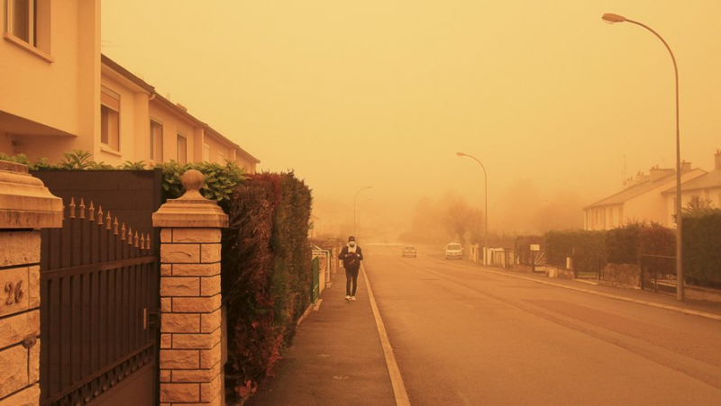
Des remontées de sable du Sahara colorent l'ambiance ce samedi 30 mars. Illustration MAXPPP – NICOLAS GOISQUE
Un week-end plutôt maussade côté ciel se précise. Ce samedi 30 mars, le ciel est chargé de sable venu du Sahara, donnant un aspect sépia au paysage. Des pluies orageuses sont également attendues.
This year, the family Easter meal will not be a picnic. Good weather is not on the agenda for this long weekend and this Saturday, March 30, a large part of the Mediterranean coast is seeing its gray sky take on yellow reflections due to rising sand from the Sahara. We take stock of what the weather has in store for us.
This Saturday March 30, the vigilance map established by Météo France is three-quarters yellow. Almost the entire south and east of the country are under surveillance mainly due to the wind and the risk of storms.
🔶 2 départements en Orange (https://t.co/CSYEovTI83) pic.twitter.com/UzDcyyvBP8
— VigiMétéoFrance (@VigiMeteoFrance) March 30, 2024
New Mediterranean episode
In our departments, a new Mediterranean episode is beginning. "During the night from Saturday to Sunday, sustained precipitation should develop over the southeastern quarter before easing on Sunday at midday. A reactivation of precipitation is expected in this area late Sunday afternoon, continuing overnight from Sunday to Monday. This Mediterranean episode should mainly concern the Cévennes as well as the departments of Var and Alpes-Maritimes, associated with significant accumulations of rain", indicates Météo France.
🌧️Pour ce #weekend de #Paques , le temps s’annonce agité sur le pays.
La région PACA et les Cévennes seront concernés par un épisode de pluies soutenues particulièrement marqué pour la saison.
Le point complet 👉https://t.co/aZkHNzOiyX pic.twitter.com/TN5NUSBvW9
— Météo-France (@meteofrance) March 29, 2024
For its part, Météo Languedoc evokes a double phenomenon. The Mediterranean and Cévennes episode, which could give rise to "marked hydrological reactions", "due to previous episodes which gave rise to significant quantities significant water since the beginning of March.
A strong sea wind
The wind will blow strong this weekend too. "As it passes through, the sea wind is active with gusts of 60 to 80 km/h in the interior of Gard but up to 100 or 110& ;nbsp;km/h on the low plains of the Gard getting closer to the coast as well as on the limit with Hérault", underlines Météo Languedoc.
Sand of the Sahara
This Saturday, a large part of the territory can also observe the particular color of the sky, due to the rising sand from the Sahara.
⚠🐪 Les quantités de #sable en provenance du #Sahara seront notables dans le ciel de l'Est de la #France et notamment du Sud-Est samedi. Les pluies/averses pourront donc se mélanger aux poussières sableuses attendues. #meteo pic.twitter.com/IYWxtyhfdw
— Anthony Grillon 🌪 (@AnthoGrillon) March 29, 2024
Combined with precipitation, this dust should leave yellow marks on your terraces or cars. For the day of Sunday, Gard is kept on yellow rain, flood and wave-submersion vigilance, while vigilance is lifted in its neighboring departments of Hérault and Aveyron. Lozère remains on yellow rain-flood alert.
Related Posts
-
 Last general meeting of the president of the neighborhood committee Jean-Jaurès
-
 “I commanded a unit of ten soldiers in Afghanistan,” says the new police chief of Pont-Saint-Esprit.
-
 He wanted to perfect his technique: a trainee pilot tries to enter the cockpit of a plane in mid-flight three times
-
 Fear of bees, limited access to nurseries, Panda raid… the main news in the region