
Agglo de Lunel: greenways for growing active mobility
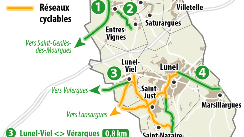
La carte simplifiée des voies vertes déjà en service sur l'Agglo de Lunel.
Avec la récente jonction des Agglo de Lunel et du Pays de l’Or, le territoire ne cesse d’augmenter le maillage.
Even if his name is “gentle”, he prefers the name “active”. "Already because’you have to make a physical effort, underlines Loïc Fataccioli, 6th vice-president in charge of mobility and transport at Lunel Agglo, to explain his choice. But also because it corresponds to the reality on the ground. Even though we are almost at the beginning, these travel networks are only increasing."
Whereas the “any car” will slam on the brakes. The ban on motorized vehicles on the municipal road which allowed the junction of the greenways of Lunel-Viel and Valergues – therefore of the Agglomeration of Lunel and that of the Pays de l’Or – is a very recent example (its inauguration took place on February 13).
A network with 245 km of circuits
So here we are at the dawn of a new era of great mobility in the open air. "A “tipping point”, continues the intercommunal elected official, also mayor of Boisseron, with mentalities which have evolved considerably in this direction since the beginning of the 21st century."
Elsewhere like here, with the satisfaction of a network which does not have to be ashamed of its figures: 25 km of greenways, more than 35 km of cycle facilities, without forgetting 185 km of labeled mountain bike circuits.
All set to expand – if not every month, at least every year – to obtain an ever-larger network and ever closer to the wishes of current and future users.
Three projects in the saddle
Since the beginning, the routes have only grown in scale and three projects are currently on the calendar (read below) in order to satisfy an ever-increasing demand for scope of the network.
"Before, cycle routes and even more so greenways were considered a tourist issue, reduced to Sunday family walks, notes Fabien Sanguinède, director of living conditions and technical resources at Lunel Agglo. Today, we find ourselves facing major itinerant routes which allow us to go from one municipality to another, for example, but also from one territory to another. And this, with daily use increasingly part of the lives of the inhabitants of Lunelois."
New means of transport
D’as much as the electrically assisted bicycles (VAE) and motorized scooters that have appeared in recent years have increased this phenomenon – and this desire – for gentle and active travel.
"The days when we had 3 to 4 km of tracks are over. With these new means of transport, there are no limits…", assures the manager.
Practical information and details
SkillWith the transition to an urban area on January 1, 2024, Lunel Agglo has inherited the responsibility for travel (other than buses) in its own right and will become, as such and in July 2025, a mobility organizing authority (AOM) with the same titles. than other towns in the department.
Terms Who says cycle network also says different names and forms. Thus, the “band” is just materialized by paint on the ground. The “track” is separated from the road, by a curb for example. The “voie verte”, finally, is completely cut off from the road network.
RulesIn addition to the Lunel/La Grande-Motte axis, the surface of which only allows walking and cycling, the other greenways in the area are passable on foot, by bike and by scooter (including electrically assisted for these two vehicles) as well as rollerblades. Motorized vehicles such as scooters, mopeds… are strictly prohibited.
Figures For nine years, intercommunal elected officials have allocated an envelope of 100,000 &euro each year; for the cycling development of the territory.
An appreciable sum and appreciated when we know that the cost of a linear meter of a greenway is 450 €. An amount obviously variable depending on the quality of the layout and the technical constraints specific to each route.
10% of the population on carpooling sites
With 5,000 people from the Lunel agglomeration community (i.e. 10%) registered on a carpooling site, long gone are the days when the carbon footprint meant nothing to those administered, any more than respect for ;rsquo;environment by thinking differently about its movements.
However, the file for the first greenway dates back fifteen years and the policies of that time – notably Hervé Dieulefès, mayor of Saint-Just and vice-president within the former -Pays de Lunel – were the precursors of an intercommunal plan for gentle travel on the cycling potential of the territory and the way to develop its network.
"This made it possible to act on two sectors, explains Fabien Sanguinède. Give the tourist office the opportunity to create labeled mountain bike trails and work with municipalities to encourage them to create cycle paths with the technical and financial support of the community institution."
Reach Villetelle via the Ambrussum site
After the five existing greenways (see details on the infographic), three other projects are being studied within the walls of Lunel Agglo. The first will consist of connecting Lunel-Viel and Lunel via the south of the RN 113, arriving in the Pescalune city at the 4 Saisons zone.
Which will allow you to follow the existing cycle path to reach the heart of the city. Currently under project management, the study should result in the launch of work in the second half of 2024.
Although the other two projects are at the feasibility study stage, they nonetheless remain attractive and attractive on various levels. Like the greenway which would go from Villetelle to Lunel via the Ambrussum archaeological site.
"On the one hand, this achievement would meet the need for daily travel, particularly for students from Ambrussum middle school and Victor-Hugo high school< /em>, is satisfied with the living environment and technical resources director of the Agglo. On the other hand, it would be a walking route which would connect with leisure cycle routes and mountain bike circuits in the department until reaching the Pôle d’ ;rsquo;multimodal exchange (Pem) and thus return to Montpellier and Nîmes by train."
Modeled on the Pescalune Loop
An assumed wish to also make the territory known to as many users as possible, from the surrounding area as well as from neighboring territories. This will probably be the case with the third project, also at the feasibility study stage, if it sees the light of day.
This would stick to the existing Pescalune loop, a hike certified by the French federation. Very busy because close to Lunel with an immersion in the heart of wild nature in a few minutes, it follows the banks of the Lunel canal until the confluence with the Dardaillon up to the bridge of the same name and a return to the city of Pescalune by the commune of Saint-Just.
"And why not take the route further north to reach Lunel-Viel…" , imagines Fabien Sanguinède. And thus connect Lunel through the first project… The circle would be closed. With, always in sight, a structuring network for entering and leaving the territory.
I subscribe to read more
Related Posts
-
 “Be there where we can change the situation”: Roderick Cox, the future musical director of the Montpellier Orchestra
-
 He denounces “20 years of harassment by Social Security”: a doctor is suspended because he prescribed too many sick leaves
-
 The cultural project of the Boudon hotel in Nîmes starts with a musical season
-
 Nearly 1,500 people united against the National Rally in Béziers