
Submergence and natural risks: urbanize or not, the Regional Chamber of Accounts tackles Le Grau-du-Roi
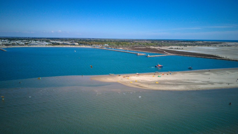
Au large de Port-Camargue, un banc de sable est apparu. Midi Libre – MiKAEL ANISSET
La Chambre régionale des comptes vient de rendre son rapport sur la commune du Grau-du-Roi et la communauté de communes Terres de Camargue. La question du développement urbain en regard des risques de submersion marine au coeur du dossier.
Robert Crauste, mayor of Grau-du-Roi and president of the Terre de Camargue community of communes, knows well the difficulties of managing housing and human activity by the sea… Since this year, he has been vice-president of Anel, the national association of coastal elected officials, whose congress he had, moreover, hosted at his home, in 2022, in the presence of several ministers . Which does not prevent him from being singled out a little harshly by the regional chamber of accounts on its management of areas exposed to natural risks.
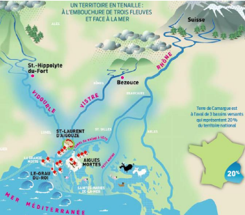
1 The coastline and the waterways
In Grau-du-Roi, the coastline is eroding: an erosion rate of 58.4% (according to a 2018 study) compared to 25.8 in Hérault and 13.6% in OPs. The municipality therefore appears at the forefront of municipalities for the number of housing units threatened in 2040 in the event of increased erosion of the coastline (with 271 housing units concerned). The Chamber notes that in the Capelude sector, where more than 50% of the coastline is covered by groynes built between 1975 and 1997, the latter have become ineffective. with a retreat of the coastline of 1 to 2.5 m per year. The beach located opposite the Barronets pond has experienced even greater decline: between 7.8 m per year between 2009 and 2018, weakening the dune cord, which could cause submersion during storms and " “a breach at this level of the coastline could expose an entire part of the intercommunal territory, with significant socio-economic issues (salt areas, agricultural areas, vineyards and activities linked to tourism) but also environmental issues”, underlines the report. Conversely, on the western tip, the Espiguette is growing (more than 9 m per year on average). This coastal drift, oriented from east to west, is estimated at 200,000 m3 per year. It is one of the most important in the region
According to a study published by Symadrem, in 2100, in the territory of Grau-du-Roi, the average annual damage (AMD) linked to marine submersion could reach between 3.88 M€ , if sea level rises by 56 cm, and 9.41 M€ if this elevation is 77 cm.
2. Urban planning: "not up to the mark" :
The Chamber is quite strict on taking into account these natural risks in terms of town planning. The horizon envisaged by elected officials does not exceed 10 to 15 years and measures to recompose the territory in the face of future rise in sea level are not envisaged. the report notes that "The flood risk prevention plan (PPRI) of Grau-du-Roi considers a strong hazard of marine submersion or flooding as soon as the water height exceeds 50 cm , which has strict consequences in terms of constructability. Surprisingly, an exception increased this threshold to 1 m in the Gard Camargue on the grounds that this « territory is entirely constrained by the risks of flooding. In the viewfinder: the eco-district planned on 6.6 hectares which should accommodate 460 housing units and a thousand additional residents.
As for the existing situation, the Chamber points to a lack of monitoring of measures aimed at reducing the vulnerability of buildings. The Gemapi competence (management of aquatic environments and flood prevention) taken by the Community of Municipalities is not well managed according to the Chamber. "The intercommunality has in fact delegated the latter to the public establishments of the territory's watersheds. The cost of this skill for the intercommunity increased by 33% between 2018 and 2022 to reach €769,752, or 5% of its management costs. The CCTC estimates future costs at 6 M€ for the next 10 years. The CCTC systematically collected an amount of Gemapi tax higher than the contributions paid to public establishments in the territory's watersheds. It did not ensure that the proceeds of this tax were allocated exclusively to this jurisdiction, contrary to what the legislator intended."
The question of the NATO deposit
In France, 25% of the coasts
In France, according to Anel, 25% of metropolitan coasts are subject to erosion (i.e. 1720 km) while 64% are exposed to a risk of marine submersion. The number of housing units in mainland France affected by this hazard is 1.3 million by 2100.
Forecasts at Grau-du-roi
The 2022 IPCC report suggests a rise in the level of the Mediterranean by 0.6 to 1.1 meters in 2100 for the most pessimistic hypothesis. A projection which does not take into account the risks linked to storms. According to a Symadrem study published in 2022, the current 100-year storms could have an occurrence of 5 to 10 years by 2100. The risk of massive water ingress by marine submersion in the large Rhône delta is estimated at 65% before 2030 and at 99% before 2050. That urbanized areas are affected is estimated at 10% before 2030 and at 40% before 2050.
Hydrocarbons
Near Espiguette beach, in an area of around twenty hectares now classified as Natura 2000, the NATO fuel depot has been located since 1957. That is, six semi-buried hydrocarbon tanks (66,000 m3) supplied by a pipeline from Bouches-du-Rhône. The site is today classified as Seveso Seuil haute and the commune of Grau-du-Roi did not fail to warn of the significant erosion of the coastline in this area as well as the risks of submersion. According to the report of the chamber « in view of the environmental issues and the strategic nature of this installation, on a military level, it seems desirable that its repositioning be considered. This could be one of the first spatial recomposition measures carried out in this very exposed territory. »
3. The limits of Terres de Camargue
The obvious conclusion according to the authors of the report is a questioning of the very existence of Terres de Camargue. A community of municipalities whose size (20,500 inhabitants in three municipalities Aigues-Mortes, Le Grau-du-Roi and Saint-Laurent d'Aigouze, 120,000 at the height of the season) and resources would be too small to continue. It is also poorly "integrated" : each of the municipalities having retained most of their skills. Who to turn to ? A strategic choice will become necessary: either join the Agglo du Pays de l'Or, which has similar tourist attractiveness assets but the same difficulties regarding exposure to natural risks (and little land), or turn towards the north. "This option could lead to the creation of an intermediate intercommunity between Nîmes and Montpellier with more land resources to think about a spatial reorganization in the face of rising sea levels, but less focused on coastal issues. This strategic choice must be decided on a territorial scale. However, it seems essential that this reflection fully integrates the issues of exposure to climate change so that the scope of the future intermunicipality makes it possible to think about the evolution of the territory and its progressive spatial recomposition."  ;writes the room which therefore invites a certain height of view.
Also read: Despite the risk of marine submersion, the mayor of Grau-du-Roi wants to "keep a city alive"
I subscribe to read more
Related Posts
-
 War in Ukraine: four Russian oil refineries hit, sale of Kaspersky antivirus software banned… update on the situation
-
 Drug trafficking in Montpellier: “Managing it from prison is impossible, you have to be on site” swears Laurent Morcillo
-
 Justice seized, action plan, subsidies cut… the decisions follow one another after the controversy over the Stanislas high school
-
 Heavy goods vehicle against car: in Gard, an 80-year-old driver dies in an accident